Looking at Poland cleared of quaternary sediments, we can notice some topographic variety only in the southern part of the country. The rest is nothing but a vast boggy plain, which replaced what had once been extensive shallow seas and inland lakes. And so we should be grateful to ice sheets for leaving us a land covered with a wide assortment of sediments and rich in magnificent landscape features.
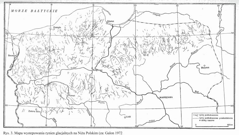
Ice sheets are the most versatile of all land-shaping factors. Direct impact of the ice mass, processes stimulated by enormous quantities of water flowing out of the ice sheet as well as periglacial and eolic processes triggered by the ice sheet affecting climate in its vicinity mean that its presence (and disappearance) in a given area leads to the creation of numerous erosion landforms and accumulation of sediments, which assume a multitude of geomorphological forms. What the forms have in common is a characteristic internal structure, including the type of sediment, composition, and the orientation and arrangement of particular components.
The presence of an ice sheet in a given area can be divided into three distinct phases: development (transgression), stagnation (when the ice sheet stays in one location for a longer period of time, which does not – mind you – mean that that the ice mass remains motionless) and disappearance (known as retreat or recession). The final phase may proceed frontally, when the terminus retreats because it melts faster than new ice accumulates, or we may talk of surface melting, when climatic conditions change rapidly enough for ice accumulation to stop before the ice mass melts away. In the latter case, melting occurs over a large area, which makes the ice sheet break into blocks with streams of meltwater flowing between them and a thick layer of ablation moraine forming on their surface. The melting of dead ice causes a range of deformations in sediments accumulated on top of it and in its vicinity.
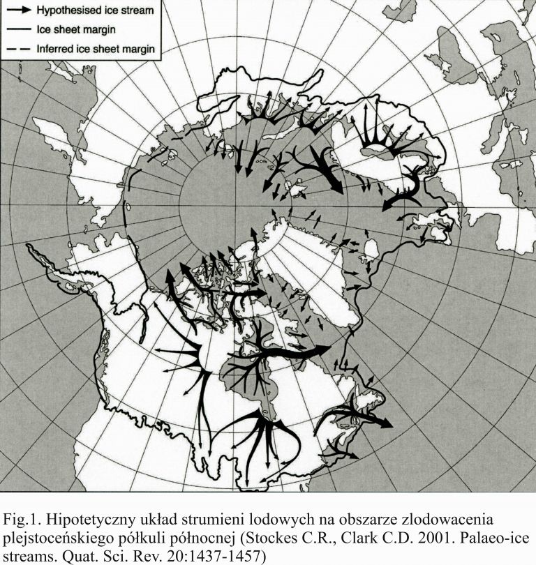
An ice sheet does not move as a uniform mass. Observations of contemporary ice sheets and glaciers reveal that different sections move at different speed, forming the so-called ice streams. Within the terminus, ice streams produce curved projections, known as glacial lobes, which are predominantly dynamic in character. Between particular lobes develop bays, where the melting process occurs more rapidly and sediments accumulate in greater quantities. Due to changes in terminus dynamics, sediment accumulations within a bay may be much greater than in other parts of the terminus.
As an ice sheet shrinks, climatic conditions in the area gradually turn to periglacial and then keep getting warmer (by definition, the climate of an interglacial period should not be colder than it is now). This brings about topographic changes caused mainly by denudation processes, such as surface lowering, slope flattening, filling in topographic hollows and valleys, or forming systems of meltwater and then precipitation water outflow. The complexity of the changes means that the remains of glacial processes are preserved differently in different areas. In some places, they are hard not to notice, while in others they can only be appreciated by the trained eye of a specialist.
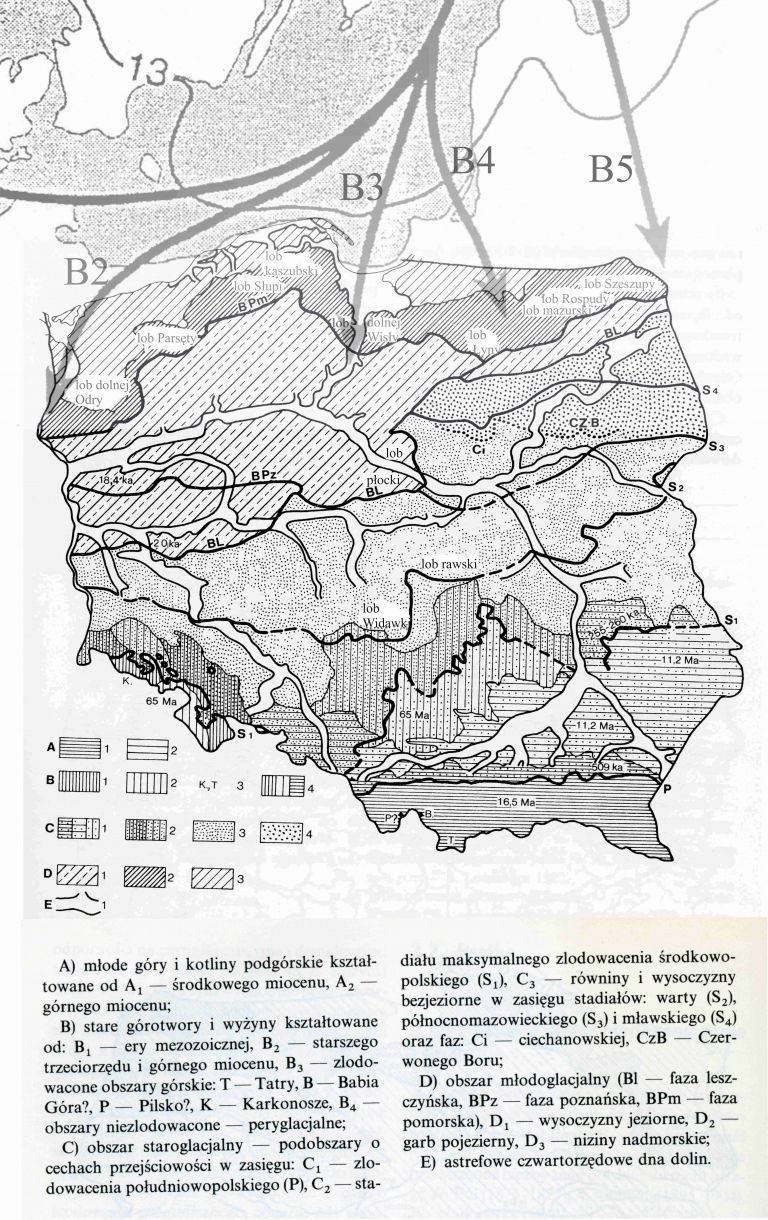
During the last glaciation of present-day Poland, known as Weichselian glaciation, the arrangement of ice streams within the Baltic Ice Cap led to the formation of smaller lobes, which is to say, the Odra, Płock, Vistulian, Mazurian and Lithuanian lobes. It is them that the large-scale topographic diversification of the area affected by the glaciation can be traced back to. The Odra lobe was responsible for the shape of the Lower Odra Valley, Szczecin Lagoon and Bay of Pomerania. In the west, between the Odra lobe and the Vistulian lobe, smaller sections – the Parsęta lobe, Słupia lobe and Kashubian lobe – can be distinguished. East of the Vistula, the Mazurian lobe shaped the landscape of the Mazurian Lake District, while the Suwałki lobe moulded the Suwałki Lake District and the Augustów Lowland (the Rospuda and Szeszupa lobes). The various sections formed at different phases of the glacial period. The phases are differentiated on the basis of increasingly detailed analyses of geomorphological forms found in the area. The smaller the forms are, the easier it is for them to be destroyed by weathering, erosion and accumulation. Another crucial factor limiting landform recognizability is time. The older the form is and the longer it has endured the impact of various destructive factors, the less likely it is to remain recognizable. This is why the topographic relief of Poland includes two large zones – the zone of old glacial landforms (stretching southward from the maximum southern extent of Weichselian glaciation) and that of young glacial landforms (within its extent). The one exception is the Podlasie Lake District, which lies beyond the maximum southern extent of Weichselian glaciation, but is characterized by what is very much like young glacial landforms. This is because the lake district left after the Warta/Odra glaciation did not “age” due to the lakes being filled in and grown over, but was instead rejuvenated by thermokarst processes.
Author: Jerzy Giżejewski, PhD


