The Arctic calls for a redefinition. It no longer resembles what it used to be a century ago. Apart from its geographical location and geopolitical situation, it is practically a whole new entity. The question arises, therefore, whether we should give it a new name or revise what the original one stands for.
Cogito Arcticus
Let us do a quick test. Jot down the first three ideas that come to your mind when you think of the Arctic. You have no doubt listed a polar bear, glacier, snow or the cold. You might have thrown in a name of an Arctic explorer or a geographical name, like Hornsund. All these associations are of course correct, but they refer to just one aspect of the Arctic – the terrestrial aspect. And yet there is more to the Arctic than the land. Even though few people associate the area with a marine ecosystem, it is in fact the ocean that largely determines what the Arctic is.
Disappearing glaciers are a fact and most of us no longer need convincing that so is climate change and the related global warming. What not everyone realizes is that the ice melts not only on land, but also on the surface of seas and oceans in the polar regions. Sadly, sea ice is not nearly as photogenic as the towering, blue-white glacier cliffs, which is why the issue attracts a lot less public attention.
Vanishing ice
The rate at which sea ice is vanishing is genuinely alarming. The most striking thing about time-lapse recordings of the ice situation around the North Pole is the seasonal variability of ice extent, with the ice pulsating like a living organism. The extent of sea ice expands in winter and reaches its maximum in March. Then, pushed around by waves and ocean currents, it melts to reach its minimum in mid-September, at the beginning of the winter season. The dates of maximum and minimum ice extent vary from year to year, but so far they have always come in March and September respectively.
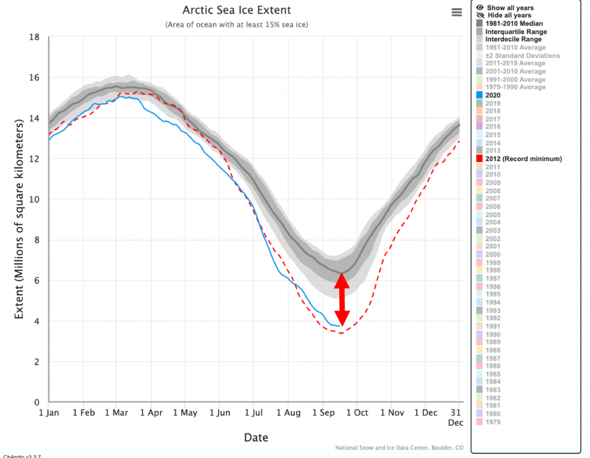
Following daily (or almost daily) updates of the ice situation on the Charctic Interactive Sea Ice Graph, one may easily notice that – as of 16th September 2020 – we are getting close to the absolute ice minimum for the year 2020, which is, by the way, the second lowest result on record (second only to one for the year 2012). The melting of sea ice accumulated in winter is now slowing down, but it is still an open question if the area of sea ice will shrink even further in 2020. The answer will only come when the ice starts to build up again and the line marking its extent on the chart begins to rise. In order to better visualize the amount of ice that has been lost, we need to compare the minimum extent values. The median value of sea ice area (which falls half way through the set of values sequenced in order of size) for a period of 30 years, from 1981 to 2010, equals 6.334 million km2. For 16th September 2020, on the other hand, it is merely 3.743 million km2. The difference exceeds 2.5 million km2, which is eight times the area of Poland (or the same as the area of Portugal, Spain, France, Belgium, the Netherlands, Germany and Poland taken together).
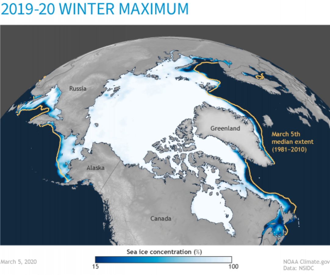
In March 2020, the ice situation was slightly better than in 2019, which was one of the worst years on record for sea ice, but its total area was still one of the smallest of those recorded in over 40 years of satellite observations. The differences in winter (maximum) extent of sea ice are not as large as in September. So far, every March, the ice reaches nearly its usual extent. So what’s all the fuss about? To answer this question, we need to change our point of view and consider the ice in terms of its age, not its area.
Multi-year ice
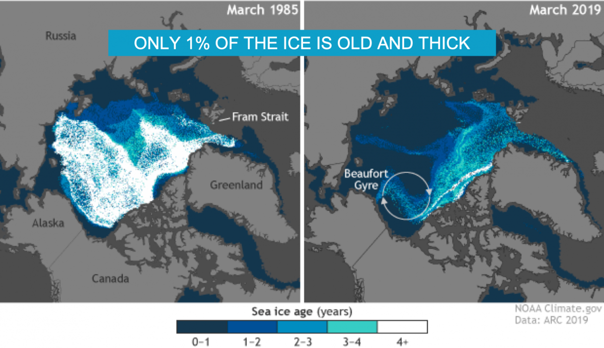
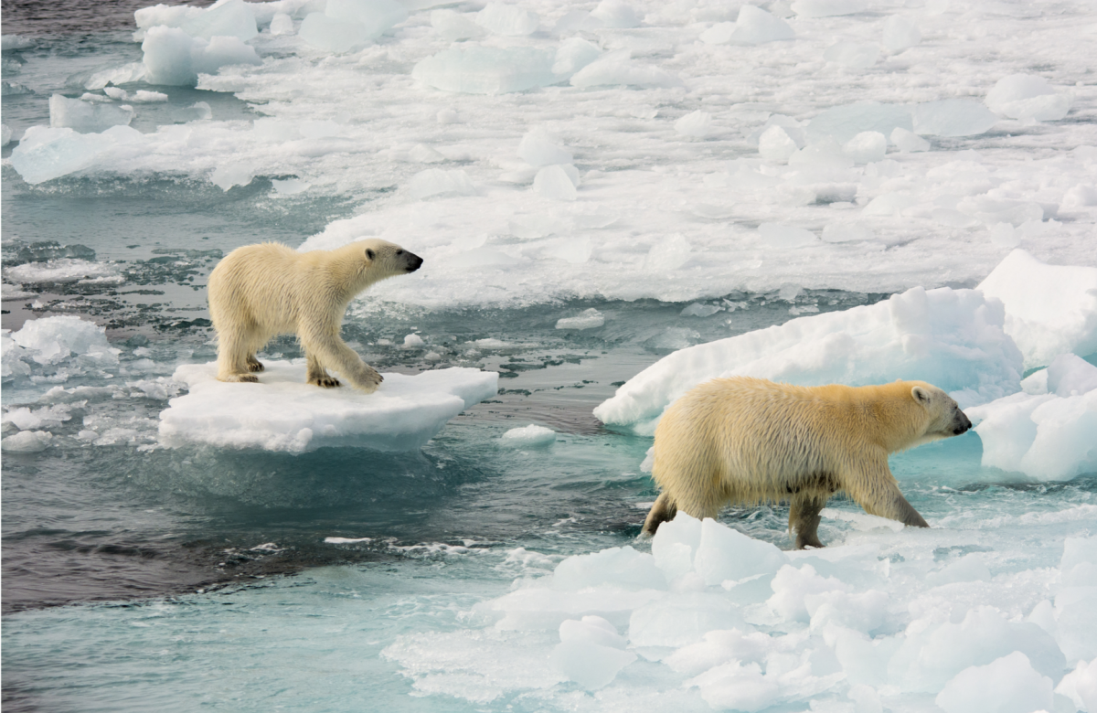
Ice has no expiry date. The oldest glacier ice in Antarctica is more than a million years old and the oldest ice in Greenland may be over a hundred thousand years of age. Sea ice qualifies as multi-year ice once it has been around for more than five years. This is when it reaches maturity, or when – by accumulating layers of snow and ice – it grows thick, with the thickness of the oldest sea ice reaching as many as 4.5 metres. Nowadays, however, a mere 1% of all the sea ice covering the Arctic Ocean is old and thick. The rest is mostly first-year ice, which is only up to 1.5 metre thick and thus too thin to last through the summer. As a result, by the end of September it is totally gone.
The older the ice is, the more irregular its bottom surface becomes. Forming ice crystals slowly expel brine through fine channels, which gradually develop into an extensive network. As a result, multi-year sea ice resembles Swiss cheese. It is full of tunnels, channels and ledges, which become progressively covered by algae. First-year ice, on the other hand, does not constitute a sufficiently stable environment for these organisms. They are just as likely to grow there as a forest is likely to grow on a meadow which gets mown every year. It is only the multi-year ice which gives algae a chance to develop enough to attract herbivorous zooplankton. Zooplankton, in turn, is food for the polar cod, other fish and sea birds. And fish are the key ingredient in the diet of seals, which are the main source of nutrition for polar bears. Polar bears depend on sea ice in yet another way – they spend much of their lives on top of it, which is why they are considered marine mammals.
Bearing in mind how crucial sea ice is for the whole of the trophic (food) chain of the Arctic, it is indeed difficult to overrate its role in shaping life in the far north. In order to do its part, however, sea ice needs to exist, which can no longer be taken for granted. To understand one of the reasons why it is disappearing from the Arctic, let us zoom out quite a bit and have a look at the Atlantic.
The Atlantic in the Arctic
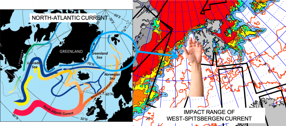
The Atlantic Ocean is linked with other oceanic basins, with water circulation between them made possible because of ocean currents. Surface currents carry warm (or at least warmish) water, which is why they are marked in red in handbooks and charts. Deep ocean currents, marked in blue, carry cold water. Europe’s moderate climate is, to a great extent, due to the famous Gulf Stream – a surface current originating in the Gulf of Mexico. The Gulf Stream flows northward, following the coast of North America, and then turns towards the coast of Europe, where it splits. The smaller currents it splits into flow further north, passing off the coast of Iceland and south-west Greenland. Another arm of the Gulf Stream, referred to at this stage as the Norwegian Current, moves along the northern coast of Scandinavia and part of it – known as the West-Spitsbergen Current – reaches the western outskirts of Svalbard.
Even though this far north the water carried by the current is no longer warm (the temperature of Atlantic waters off the coast of Spitsbergen is about 4-6°C), its impact on sea ice on the western side of Spitsbergen is undeniable. It is due to these waters that sea ice hardly ever develops along the island’s western coast. A sea ice cover can only be expected to form close to the north-western section of the coast, where the West-Spitsbergen Current loses its momentum and gives way to the waters originating in the Arctic.
This means that the western coast of Spitsbergen supports two biologically and physically different environments. The boundary between them abounds in zooplankton and thus constitutes a rich feeding ground for whales, birds, fish and – in fact – almost every other kind of living creature inhabiting the Arctic. Although the West-Spitsbergen Current has been shaping Spitsbergen’s climate and ecosystem for centuries, scientists have recently noticed that its impact on the Arctic is getting larger than ever. The Atlantic waters become increasingly dominant, influencing the Arctic’s climate, the extent of ice cover, species composition and trophic relationships between consecutive links within the food chain. The phenomenon is referred to as the Atlantification of the Arctic.
The army of the south
To understand why this is so, it is best to begin by characterizing both Atlantic and Arctic waters. The former are warmer and more salty than the latter. They are also home for different species of animals, like the Atlantic cod in the Atlantic and the polar cod in the Arctic. Zooplankton varieties found in Atlantic and Arctic waters are also different. The species inhabiting Arctic waters are adapted to extremely low temperatures. They accumulate more fat, which not only protects them from the cold, but is at the same time high in calories. This is why sea birds, fish and seals which feed on Arctic zooplankton and fish get more energy than they would if they fed on Atlantic species instead.
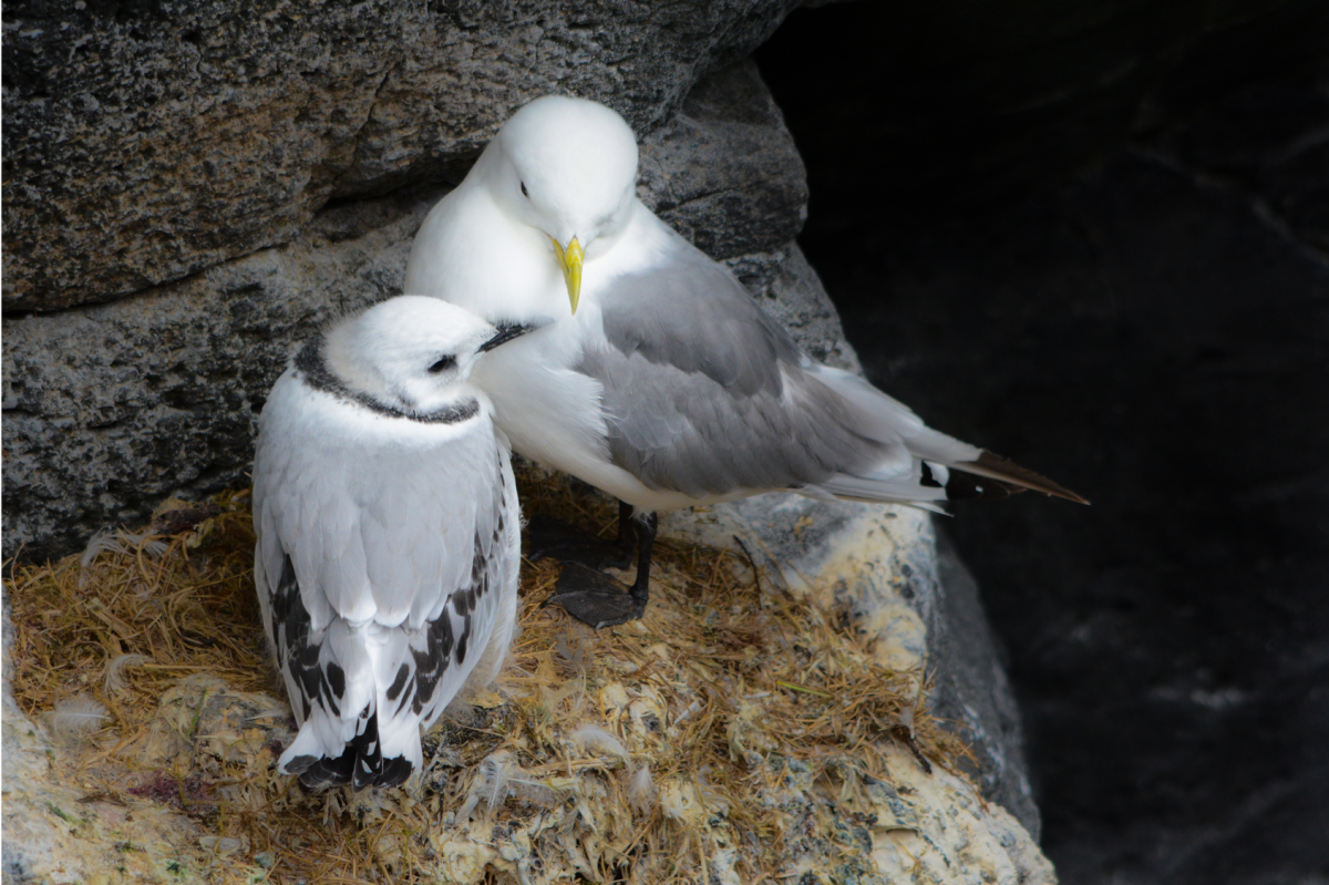
The problem is that the inhabitants of the Atlantic are becoming more common in waters which used to be inhabited solely by Arctic species. Research suggests that this has affected the diets of many birds, including the black-legged kittiwake and the thick-billed murre. In the 1980s, when the study started, black-legged kittiwakes never fed on the Atlantic cod, capelin and herring, which are all Atlantic fish species. Twenty years down the line, however, the fish was already a regular element of their diet. Scientists have also noticed that a lower calorie intake compromises the reproductive success of the thick-billed murre.
Another example are the above-mentioned cod species. The past decade has seen radical changes in the range of each of them. The polar cod is now found only in the northernmost areas within the continental shelf. It cannot go any further, because the food is only available in shallow waters. The range of the Atlantic cod, on the other hand, is expanding northwards. It is possible due to the warmer, Atlantic waters, which are reaching further north, enabling the Atlantic cod to survive in new territories. Besides, the northern areas provide rich feeding grounds. The Atlantic cod feeds, among others, on the young polar cod, which normally seeks shelter in the labyrinth of sea ice until it becomes big enough to fend for itself. With no sea ice to hide in, it is a lot more vulnerable to predation.
An interesting case, which demonstrates that the inhabitants of the Arctic can, to some extent, adapt to the new reality, is the little auk. These small, black and white birds are the most numerous species of seabird nesting in the northern hemisphere, with huge breeding colonies found mostly along the coast of Greenland and Spitsbergen. They feed on fine zooplankton, less than 5 mm in size, which they hunt by diving into the frigid waters of the Arctic. Scientists have noticed that little auks avoid hunting Atlantic species, as they provide too few calories to justify the effort.
Instead, they are known to travel even 100 km from the colony in search of the high-calorie Arctic zooplankton. Once their chicks have hatched and need a constant supply of food, they may do so up to several times a day! Little auks have been observed as far as 150 km off the coast of Spitsbergen, near the ice pack, where their chances of finding quality food (most abundant in the vicinity of sea ice) are the highest. Each year, however, the edge of the ice pack lies further and further from the coast of Spitsbergen, which begs the question: How far will prove too far for the little auk? At which point will the birds be forced to feed on Atlantic zooplankton and face the risk that it may not provide enough energy for their growing chicks?
Epilogue
From the point of view of politics and economy, the gradual disappearance of sea ice in the Arctic is seen as an exciting opportunity for the development of maritime transportation across the North Pole and a chance to gain access to new oil and gas deposits. In terms of biological, ecological, climatic and cultural value of the Arctic, sea ice disappearance means profound changes, which we are now witnessing and which are yet to be fully understood. Will the Arctic become completely ice free? Will it finally surrender to relentless Atlantification?
Scientists believe that it will take no more than 30 years for all the ice around the North Pole to melt. The waters of the Atlantic which reach the edge of the ice pack affect it both from the top (by warming up the air and thus accelerating the melting of ice surface) and from the bottom. Constantly on the move, the waters flow under the ice and a layer of very cold water, known as the halocline, found underneath. It is the halocline that insulates the ice against the warmth brought in from the Atlantic, but its protective capacity is negatively affected by the growing inflow of Atlantic waters. Without the halocline there is no hope for sea ice. Without sea ice, there is no hope for the halocline. All that is left is the Atlantic.
Text: Liliana Schönberger (Keslinka), PhD
Translation: Barbara Jóźwiak